The present town of Builth Wells is situated on the junction of two main roads, the Swansea-Manchester A483, and the Cardiff-north Wales A470. The railway has long gone, a victim of Mr Beeching, though the Heart of Wales line runs just 2-3 miles away, with halts at Cilmery and Builth Road, as well as the town of Llandrindod Wells. 

The site of the Royal Welsh Show is just across the river at Llanelwedd, with the show itself being held in the latter part of July. The showground also hosts a wide range of events from rallying to dog shows, from sheep sales to camping exhibitions.

Accommodation can be provided in several bed and breakfast establishments or one of the hotels in or around the town. Builth can prove to be an ideal base for touring Wales and the Marches. Local buses ply between neighbouring towns and villages, and the larger towns of Hereford and Newtown, or you can hop on one of the Post Buses and see some of the more rural areas.

Buzzards and the red kite can be seen soaring over the town, often mobbed by crows or jackdaws. A walk along the riverbank reveals ducks, swans, herons, visiting geese and the occasional kingfisher as well as keen fishermen seeking coarse or game fish.
The Town
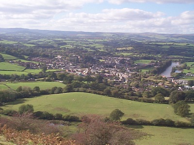
A view of Builth
Though not a large town, it can still boast a post office, banks, an art centre cum cinema, hospital, doctors, fire, police and ambulance stations, vet, dentist, estate agents and a range of shops including a small supermarket.

The livestock market is now held on Fridays instead of the traditional Monday, and there are several special sales of sheep, cattle and horses either here or on the RWAS showground.

Llanelwedd Arms
Wyeside Arts Centre
Mural of Prince Llewelyn
High Street
The Drovers
Cobble Lane aka Ruth Lane or Steepy Lane
A view of the river Wye upstream from Builth bridge
Police Station
Fire Station
Hospital
Drs Surgery
Car Parks
Toilets
Castle
Wye Bridge
Swing Bridge
Irfon Bridge
Map of Builth with some useful links. Just move curser over the names at the side for more information. May not work with some browsers
Image produced from the Ordnance Survey Get-a-map service. Image reproduced with kind permission of Ordnance Survey and Ordnance Survey of Northern Ireland.
MAP OF TOWN
The view from Garth Bank over the town towards the Cambrian mountains